This is a great mountain river that is fast and sustained when it's up. With a lot of rapids, from small drops to long bouncy sections.
The Liffey needs a bit of rain to get it working, but as it's on the windward site of the Wicklow mountains (the side that most of the weather comes from) it is not always up when the rest of Wicklow is working. Driving to Wicklow via the Sally Gap is traditionally a way to check it and then move on to other rivers.
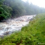
If it is up the first section visible from the road will have most of the rocks covered. If all the rocks are covered and the first section appears flatter and washed-out then the river is in flood and a grade higher at least.
Also be aware that streams downstream add considerable volume to this run.
At the put-in there is a piece of the bridge in the river a metre down from the bridge. It is flat and at a right angle to the flow.This is a good gauge for the level. If the water is flowing over it the river is runnable. If you can't see it at all it is high. Care must be taken with judging the level as it can fall or rise quickly while you are on it. It is advisable to have someone who knows the river with you.
After you get on the river starts out with a section of sustained rapids of Grade 3 which can have some small stoppers with a bit of grip. This section is quite close to the road and the banks are low; if you are not feeling comfortable on this section it would be wise to hop off now while it's easy to do so.
After a few bends the rapids slow and a flat section is reached. after this flat section there is another bridge this one is bigger and has been rebuilt in the last few years, there is a lip under the bridge that could cause problems to the unwary at certain levels. Just downstream the nature of the river changes and things get interesting.
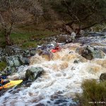
From now on the rapids are long and vary from little rock gardens to boulder dodging and at times can link into one another. The banks are now higher but egress is still possible for scouting.
The rapids continue and the gradient steps up the drops become bigger and the boulders bigger.
In high water this middle section can have some stoppers to catch out paddlers, but at normal levels it is a blast. Twisting through the boulders in the middle of long rapid will make even the sternest boater smile.
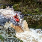
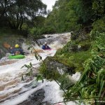
After a right-hand bend the river picks up gradient and the banks enter a valley with steeper rapids and trees overhanging on the right. At the end of this section there is a drop followed by a short pool section. This is the run in to Coronation Falls . Inspection/portage on river right.
The run in to this rapid changes regularly from one to two channels, so check if you dont want any surprises.
The drop it self is a narrow 1M gap between two rock banks. Most of the flow pushes right to create a big cushion wave. Almost all paddlers go deep on this one either intentionally or not.
After the flat pool at the bottom of the falls the gradient eases off. It is now 2 km of easier paddling to the get-out with only an weird ford across the river at a gravel pit to be careful of.
This river is really one of the best Grade 4s in the country. It is sustained and challenging, but describing it drop by drop is nearly impossible as there are lots and lots of rapids. It starts off bouncy gets into longer tricky rapids and finishes with a nice drop but keeps you alert all the way down.
After the floods earlier this year 2012, some changes have taken place, at the first real Horizon line there used to be trees overhanging river right these are now reduced/gone.
Trees - one large one down after 2km, must portage. Also banks are lined with trees in sections. Bridges - Duck!! One at get in (advised to put in after this) and one 1km into paddle. Coronation falls - Inspect/rescue/portage. Road ford - Shallow at times with river flowing under a concrete slab through narrow pipes, at high water could be a sieve hazard.
At medium level a strong tow back forms on the stopper on the other side of this ford. The stopper becomes a problem when the road itself kills momentum and you could end up drifting into the stopper. There is a scrapey line on river right but it's worth getting out to have a goosey at it. The tow back is about 8 feet long and will hold a swimmer.
Only park in the parking areas at the put-in and take out. Parking on the main road will cause mayhem as it is a narrow road. I think the quarry no longer tolerates paddlers taking out at their ford so it is better not too. Keep valuables out of sight in parked cars.
Online gauges page is here: Gauges page
The Upper Liffey gauge on twitter is here: Upper Liffey gauge
Flat rock just dowstream of put-in bridge. Just covered = runnable Flowing fast over it = optimum. Rock cant be seen = high River flowing flatish after bridge with water nearly into the parking = very high.
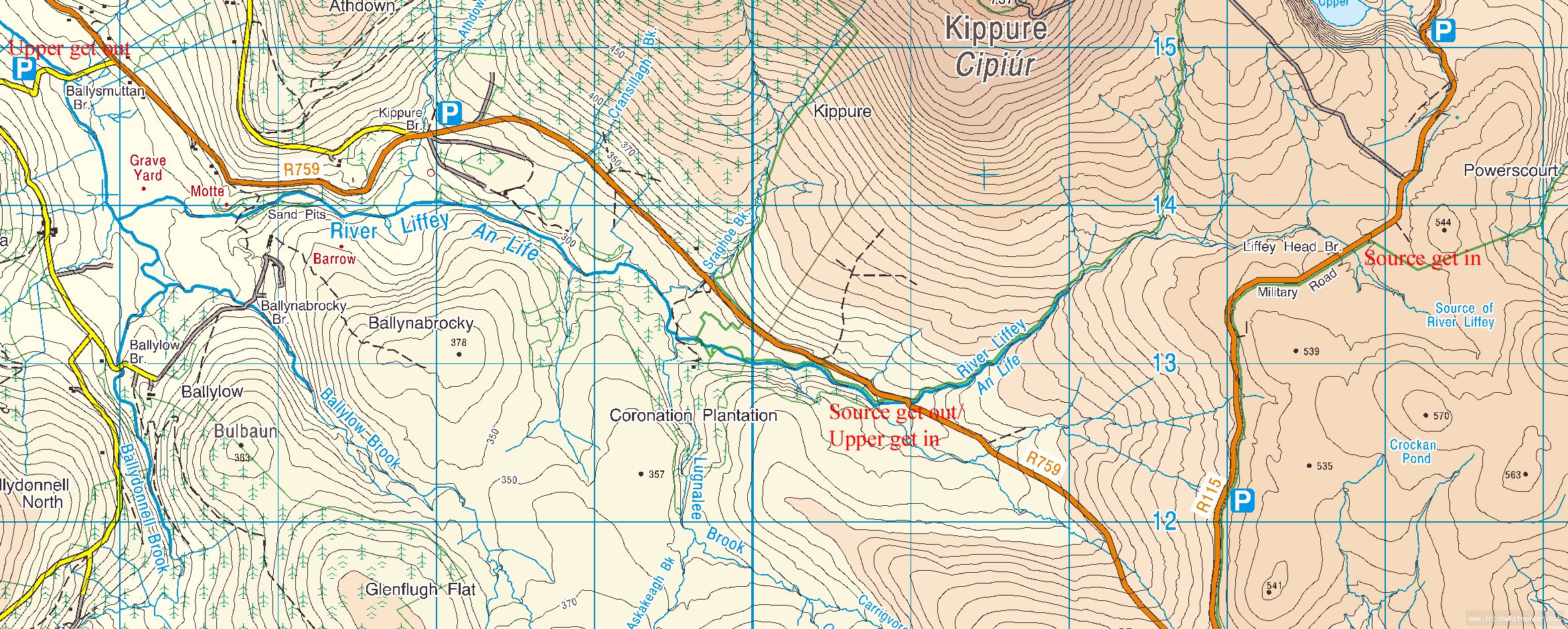
The Upper Liffey is located on the western side of the Sally gap about 2 km west of the crossroads on the R759. The put-in is at the first road bridge, where there is a small lay-by/parking space. Grid ref O(109,128)sheet 56. There is a low broken bridge 50 mtrs downstream which most will put in after as it can be tricky to get under.
Take out is at Ballysmuttan bridge GR o(056,148) on the Manor Kilbride road. This road is the first left turn off the R759 7 km aprox. from the put-in. There is a lay-by on the right after the bridge. Caution: The Sally Gap road is known for break-ins, especially the put-in. Keeping valuables out of sight and parking in view of the road will help.
Interactive map loading...
Upper Liffey
Peter