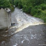
Grade 3 in high water and grade 2/3 in medium water. Good for either creekers or playboats at any level. Its a great river for beginners, as gear is easily retrievable and swims are short.
Get on the river at the end of the green and 100m downriver you come to the first weir, a 10ft slide. Easy lines river right but beware river left as there are a lot of trees. When the river is high,there is a wave with a strong stopper. Playboaters beware as you could be in for a loop! In medium water its just straight through. Fast flowing water just after with plenty of eddies and an especially large eddie further down on river right that's good for re-uniting boaters with gear!
Continue on down river until you come to a broken weir. River left in high water boasts a good boofing opportunity over a rock table. River right has a green water shoot straight down the weir. You can also catch the tricky re-circulating eddie in the very right corner.
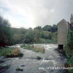
Continue on from here until you come to the first bridge in Navan town. The weir here is best run down beside the building past a large stone extending out into the river though it can be run anywhere. Beware of hidden rocks. Do not go through the building itself. Continue on down the river and you go under the second bridge.At this point the Blackwater meets the Boyne and continues down towards the ramparts in Navan and the 4th weir.
The ramparts weir is a diagonal weir which can be run down a shoot at the top on river left, or down at the end of the weir, a nice boof can be obtained.You can pull into the eddie river right,climb up the wall and run it again and again. The weir itself has a strong towback and I don't think it would be wise to try and surf it as the water flows across the weir, not down it. Its like its slightly undercut
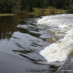
Continue on from here and you pass by a few dinky rapids. There are a few surfing opportunity's as you paddle downriver but there isn't anything technical or sinister. The next main obstacle is Ardmulchan Weir. This is a high weir that can have a strong stopper. In very high water, river right down the weir is just a wave through. Halfway down the weir then holds a very strong stopper. In medium water,there is a nice height to the weir with a wave at the bottom and a stopper either side. Surfable and a nice playspot.
As you continue on down towards Stackallen, you come to another few small rapids. Then you go under the bridge at Stackallen and down to Stackallen Weir and the take-out for this section on river right. You can do Stackallen weir and either pull in river left and paddle back up to the bank and get out,or continue on down to the broken weir, play there and get out river right and walk back up to the cars through the field.
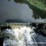
This picture is of the weir under the bridge at the new road in Navan. Now I know this doesn't look like much, but it is! It will loop a smaller boat and maybe hold and flip a boat that doesn't have any momentum.
Also in the picture at the right of the weir is a large hole that is retentive, don't go there. The best place to run it is at the top left of the weir, missing the stopper completely. This river is super at this level, but as always on any river be aware of whats goin on, safe paddlin guys.
River access at the back of the building at the get in is easy. Just keep in mind that we want to be able to keep using this as the put on, so no messing. At the get out make sure not to block the entrance to the houses. Also cars and vans have previously been broken into there so remember not to leave any valuables in sight.
Loading levels...
Written by paddlers. If you know this river, sign in and edit these notes. Changes are reviewed before they appear.
If you look at the river from the new bridge in Navan and you see a lot of rocks at the weir, its at low level. Or if you see a small rock island in the river at Flowerhill bridge its low. If there are no rocks to be seen, its at a nice level.
Typical number of days each month the river is at a paddling level
| Month | Typical paddle days | Driest year | Wettest year | Years with at least one paddle day |
|---|---|---|---|---|
| January | 31 | 12 | 31 | 8 of 8 |
| February | 28 | 17 | 29 | 8 of 8 |
| March | 31 | 12 | 31 | 8 of 8 |
| April | 13 | 0 | 30 | 7 of 8 |
| May | 2 | 0 | 14 | 5 of 8 |
| June | 0 | 0 | 6 | 3 of 8 |
| July | 0 | 0 | 17 | 1 of 8 |
| August | 0 | 0 | 26 | 3 of 8 |
| September | 0 | 0 | 15 | 3 of 8 |
| October | 16 | 0 | 31 | 6 of 7 |
| November | 30 | 4 | 30 | 8 of 8 |
| December | 31 | 11 | 31 | 8 of 8 |
The best months on the Blackwater/Boyne are January, March and December, with 31 paddle days in a typical month. Summer is hit and miss: a typical June to August month gives no paddle days, but July had at least one paddle day in 1 of the last 8 years.
How to read this graph. A paddle day is a day the gauge reached the guide's Low level (1.1 m). Each bar is the middle year of 8 (2018 to 2026). Tap a bar for the driest and wettest years.
How high the river usually gets each day, from 8 years of readings (2018 to 2026)
| Month | Typical daily high | 8 days in 10 between |
|---|---|---|
| January | 1.425 m | 1.112 and 2.171 m |
| February | 1.607 m | 1.099 and 2.385 m |
| March | 1.506 m | 1.032 and 1.984 m |
| April | 1.124 m | 0.902 and 1.548 m |
| May | 0.939 m | 0.798 and 1.146 m |
| June | 0.847 m | 0.7 and 1.002 m |
| July | 0.784 m | 0.709 and 0.917 m |
| August | 0.762 m | 0.648 and 1.367 m |
| September | 0.752 m | 0.694 and 1.315 m |
| October | 1.178 m | 0.74 and 1.871 m |
| November | 1.58 m | 0.764 and 2.096 m |
| December | 1.498 m | 1.108 and 1.994 m |
How to read this graph. The line is the typical daily high; the shaded band covers 8 days in 10. Dashed lines are this guide's levels.
Past levels are no guarantee of future conditions. Readings can be late or wrong: check the river on the day. Level colours, "Running now" and paddle days are a guide only, not a sign that the river is safe to paddle. Read about gauge data and levels.
Levels for this guide: whitewater.guide (CC licensed).
Contains Irish Public Sector Information licensed under a Creative Commons Attribution 4.0 International (CC BY 4.0) licence (source waterlevel.ie, provided by the Office of Public Works).
This section of the Blackwater and the Boyne is located just outside Navan town. Drive out the main Navan-Kells road.
There is a small roundabout. Take the 3rd exit which leads you into the grounds of a large building. (If you pass by a Woodies DIY store you just passed the turn off) Continue down around the back of the building and you will see the river at the end of the green. There is plenty of parking available.
Go back into Navan and at the second set of traffic lights, take the left up the new road. Go through the traffic lights and at the roundabout, take the second exit past the Round O pub. From here continue straight out the N51 road.
Around a 10 minute drive you approach a Shell garage on the left with a junction just after. You take the right turn and continue on straight for around 2/3 mins. You cross a bridge and take the left intermediately after. This leads you to Stackallen.
The take out for the Blackwater is also the Put In for a classic run, the Boyne. Check out the river guide for the Boyne in Co.Meath.
Interactive map loading...