The river requires a lot of water to be runnable. Grade 3 to 3+ stuff. Starts off in a small forestry and continues down the valley through Glensheelan Woods. A rough walking path follows the river most of the way down.
The put is on the Monavugga River, this meets the Glenafalla River, which then meets the Glensheelan River.
As the river is only runnable at one level high here it is. The forestry is widely used by scouts and guides so there are a lot of make shift foot bridges across the river at the start. Once down in the forestry find somewhere deep enough to float your kayak get in here, just after a washed out foot bridge stuck in the river bed.
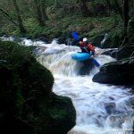
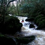
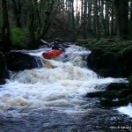
A short shallow run leads you into the first boney 3ft drop, run centre. Debris clogs the river after keep left and follow the flow. A slab drop with two out reaches is the next 2-3ft drop keep left drop off and make for centre and on through the next few easy rapids. There are no serious rapids for a while after this and your next worries are trees. Collite control the forestry here but have no regard for trees in the river be careful if you see a tree eddy out early and walk around.
Eventually you reach a large clearing with huts the scouts use. From here on the river starts to flatten out a bit.
A horizon line appears this marks the start of a bit more whitewater. It impossible to see whats on the weir till your going down it but dont worry its fine. 6ft slide and a few easy rapids later you back on to moving flat water which continues to the get out.
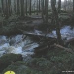
Fallen trees and branches of larger trees hanging or lying in the river bed. Dont chance it get out!
None that we know of. Just be careful about parking not to disgruntle the locals and try to avoid wandering into private land at the get out. At the Grotto at the get in it can be very busy during the summer with visitors park with respect. First Decent Accredited to Tony Walsh, Kevin Jennings and Michael Flynn
Check flow at get out when setting up shuttle. But it needs loads of rain so you should know anyway if there has been loads a few hours constant rain or a two days steady rain.
The river flows out of the mountains around Mount Mellary Abbey near Cappaquin, Co. Waterford. To get to the put in head into Cappaquin, then follow the sign posts for Mount Mellary Abbey. On a dip in the road before reaching the abbey you come to Mellary Grotto. Park here. Carry your boat from here around the bend and down the lane by the potters cottage and on into the forestry.
Depending on water levels as with all of Waterford river you can extend your run. Best bet is to park in the car park at the end of the walk through Glensheelan Woods and make this your get out. Otherwise park close to the GAA grounds in Cappaquin, this is where the river meets the Blackwater. You can get out here too.
Interactive map loading...