One of three Waterford rivers featured in Seamus MacGearailt’s 2nd Edition of “The Irish WhiteWater Guidebook” P48. A good run with technical sections and evenly spread drops, you’ll find it on OSI ’s Discover Series 74 & 81. If you get medium to high water loads of fun to be had, the river lends itself nice to being run a number of times in a row.
If there is super high water there is a playwave on the Blackwater about 0.5km upstream of where the Owennashad river meets the Blackwater. Some photos are in the Owenashad gallery.
Starting from where you parked at the top of the small hill. Walk back down the hill to meet the main road again. Just here the river passes under a small bridge, under the main road. Look over the left of bridge here. If your an advanced paddler and water level permitting you should turn left onto the main road walk up from here till you have found a gap in the wall to get through.
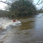
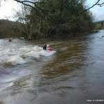
The first 500m of the river from here is very technical. Lots of little drops, with little time to prepare or make corrections to ones path. You can scout only up as far as where the river crosses under the road bridge from here, a farmers water pipe hangs low under the bridge. The rest can only be scouted from the road.
After the bridge walk on the left hand side of the road and take your time to have a good look at all the drops, this section continues for about 300m by the road, until you meet a gap in the wall, marked by a big telegraph pole. There is a path down to the river by going through the gap and down to the left, a rope on you right installed by fishermen is very handy, we also put in a few pegs as steps which also help. Its very slippery, so be carefully. At the bottom you have a good view of the last drop on the very technical section, the very end of this is quite narrow in low water. This spot is also a fun starting point if you wish.
There is a nasty syphon at the end of the upper technical section, it can be seen in low water. As long as the river isn't in spate there are two big eddies on river left above the siphon where one can get out, its is then possible to get in again beside/below the siphon. Please carefully consider if its worth running the section above the rock launch when its high.
At this point your still high off the water but the ledge is the perfect launching point, a 15ft drop into deep water. Fun! Not advisable in high water because you get washed into the river right bank. A better start for lesser paddlers is another short walk down the road, the next gap is an easier climb down to a flatter river level bank. Over the years people have continued to dump their rubbish here, you notice it as soon as you put your foot down, watch for glass, nails, nappies etc.
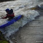
From here down is steady grade three water. Until you come to the first main drop. You will see the road bridge with three arches up ahead. Get out river right where possible and scout. Run by heading for the centre arch, run hard and centre keeping your nose up, the drop narrows as you run through and don’t capsize! The river carries with steady fun white water. You will meet a bridge with one arch which goes into the closed quarry above.
After this on river left is a gauge:
0.7 = Low
1.4 = High
2.0 = Flood
After here is the another bouldery drop, run centre, no probs! Again steady white water, 3rd drop some & some info. Again its on a left hand bend in the river. Approach from river right heading toward centre, in low water two rocks stick out from either side after closing it off, running centre is easiest way through, although messing up brings little consequence. Two small drops follow and you haven’t far more to go. The last piece of white water is where the river runs into a large flat boulder right left, pushing it river right. No hassle stay with the flow. After this it gets scrapey in low water with a small rock garden that some times requires walking when to low scrap along.
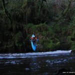
The rest of the river is flat through over hanging trees, until you come to the weir at the pool at the get out. At the weir there is a small fish box directing some of the water, this can be fun for a few ends. You can get out here and walk back to the cars or paddle a little further to the N72 road bridge and get out river left.
Lots of fallen trees on the river because a lot of the trees are fairly old and rotten, but also along the R668 Clogheen road, its not unlikely to meet a fallen tree, you‘ll notice many parks of the wall have been knocked by falling trees. Quiet a bit of debris, stuff like gates fences, pipes and other general rubbish adorn the river and banks. Be carefully of any glass or farming rubbish.
There is a nasty syphon at the end of the upper technical section, please carefully consider if its worth running the section above the rock launch when its high.
Local issues We have never had any issues with locals, just don’t park at the petrol station. Be seen, use the shop in the petrol station, don’t pee in the park and be carefully crossing the road, a lot of traffic uses this route to get to Tallow, Ballyduff and Fermoy.
While most other rivers around waterford tend to drop quite quick this holds its water quite well and is a good run. The final weir is a great little feature at the end too.
At the get out where you park, the bridge crosses the river here. At the bridge look upstream. Its usually very stoney, if the stones are not all covered its too scrapey to run don’t waste your time, if all are covered but not my much its low but running, if there is a good flow and the river is spilling over into the park flattening the grass, its well up, lots of water and good fun.
Coming from Cappoquin on the N72, heading towards Lismore. Just as you are coming into Lismore, you pass a Petrol Station on your right, take the next road to the right immediately after the Petrol Station, sign posted R668 to Clogheen.
Travel up this road for 4km, stay on the road and take the first and only turn left on this road, up a short steep hill and park just at the top of here. You know your in the right place if you can see a castley looking house in the field beside where you parked.
Back on the N72, just after where you turned right for Clogheen, there is a small parking area on the left. There is usually a few other cars parked here. Park here.
The next bridge immediately after the parking area crosses over the river. You can check the level here. A small gap in the wall across from where you park, leads in to the park, following the paths leads you to the finishing pool and weir.
Interactive map loading...