Upper Bann from Banbridge (seapatrick) to Tullylish Church Graveyard (5k) or to Gilford car park (7k).
Grade II run with more difficult stoppers on weirs in higher flows when inspection is recommended.
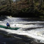
After putting in their is a few small drops that in higher flow will disappear. After this there is a Flat section, houses on the right indicate the first weir (Seapatrick Weir). This Weir is best run left or right of the fish leader, if you wish to run the ladder itself it is worth while inspecting to make sure there is nothing blocking your line.
A short paddle after this there is a horse shoe weir that can be an awesome play spot, however in higher flows can become a nasty stopper. It is possible to set safety up on river Right. A rocky section then takes you down to a small drop on river right after a short paddle there is four small drops, watch out for branches in higher flows.
Then there is some small rapids that take you to Laurence Town. With the first take out on river left after a stone bridge.
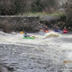
To continue on towards Gilfords paddle on down over four small waves that are all surfable in a medium flow. Paddling on down flattish water we come to another weir that is Playable in medium to high flows. Stay to river right more small rapids follow until the diagonal weir, which in high flows can be dangerous and should be inspected on the Left bank.
Then there are some small rapids until we come to the largest weir on the run. There is a nice eddie on river right just above the weir where you can inspect with out getting out of your boat.
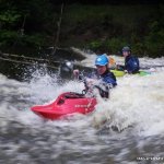
After this there is the most technical rapid that can be portaged on river right, there is a number of large eddies to inspect from the top are a quick walk down the bank to find you're line.
It is just a short paddle with one more small rapids to the bridge at Tullylish Rd., the next get out.
If you are really keen and want to make a long day continue down to Gilford this section as some small rapids and a weir.
Trees blocking weirs. Stoppers in high water.
Watch out for Fishermen as there seem to be some problems, access is not a problem.
Drive to Tullylish if there is rocks don't run as the river is low.
Head to Banbridge off the A1 from Belfast - Newry. Head out the A50 road for Gilford. Look for the hockey club on the left. Turn in and drive to the bottom of the lane. You will see a foot bridge across the river this is the Put in. There is ample parking back up the lane in the hockey clubs car park.
Drive towards Gilford on the A50 and then take the sign for Tullylish Rd. Please be respectful as there is a Grave yard at the take out. ... or Drive on to Gilford and park in the large car park beside the river.
Please be especially careful on a Sunday NOT to park close to the church at Tullylish as this has caused problems with access for church goers, and has also raised concerns from parishioners attending the church that there are semi naked kayakers changing within view!!
These requests have been made specifically by the minister of the church, who is happy to allow access to kayakers as long as they show due consideration.
Interactive map loading...