Upper Section:
is predominantly grade II to III in nature. Most rapids are easily scouted from the water. All the lines down the river are obvious. There are plenty of flat sections to collect any gear and swimmers and all the rapids are evenly spaced.
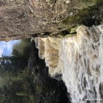
The first drop is a weir ran right on low water and left on high water. The main feature on the river is located near the end and makes for a great finish to the trip. The rapid itself is a blasted fish run and consists of four small drops that run back to back and drop about 15ft over their length. inspect right above it from the left bank or eddy out further up above the S-bend on the right if its high. The drops themselves are not technically difficult and there is a large pool located at the bottom of the rapid which makes this an ideal opportunity for beginners and intermediates to hone their skills.
This river is predominately flat along most of its course and has a large catchment area so it retains its water well. This means that after heavy rain the main falls can get altogether more sporting as the whole rapid turns into one exploding mess. Great craic altogether. It's like being flushed down a toilet! Beyond the main falls, there is one more straightforward rapid with one clean drop and a second rocky drop that a boat can be pinned on in low water.its a short paddle to the bridge and take out.
Lower Section:
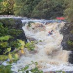
The lower section is a short , sharp paddle with 8 drops back to back in it's main section. Put in at the bridge. A few minutes down stream most of the river flows left around a small bend, just past this a cliff wall of about 35ft comes into view which signals the start of the gorge and the main section of this river. Scout on river right if levels permit.
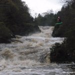
If your running this section for the first time it is worth setting up rescue and scouting the lines down the drops. This is a modest grade IV, but it can still had out a beating at the right levels. The fourth and fifth holes are the largest one of all eight and requires good forward momentum to punch through at higher levels. At the bottom of the gorge the river sweeps around to the left and is followed by one more small rapid. The is a large tree blocking the river right side of the river after the pool around the bend. While not an immediate hazard it would be something for swimmers to be aware of. Beyond this exit the river on river left(look for a path thats been cut at the end of the cliff or continue on to a electric fence where cattle drink.) and do it all again. Although this is a short run, it's well worth the effort and can be shot again and again.
Both the Upper and Lower section make for a great days paddling and over a rare opportunity to practice many modern creeking techniques in a relatively safe environment. Footage from both of these runs can be seen on Huckd (www.huckd.com). The river was at a medium level while filming.
Both the main rapids on the Upper and Lower section have been blasted to allow fish progress upstream. Due to this the bedrock of the main rapids tends to be a bit sharper than usual. Some knowledge of defensive swimming might save your backside from a few unnecessary cuts and bruises.
It is worth setting up rescue on the main falls of the Lower section if unfamiliar with the lines down the run.
The section between the upper and lower is a mess with trees and not worth the run, it also raise the potential for the Lower to have a log jam, although none have ever been noted as far as I know.
At high flows the bottom of the main drop on the Upper Section has a retentive hole.
On the Upper Section, not long after the put in there is a wire going across the river. we have cut this down before but farmer has put it up again. after you get on the river flows around a long left turn, this straightens out and then turns right. The wire is before the right turn. There is a big rusty metal thing in the river before the wire, if this is covered then you can pass above the wire on river left.None that we're aware off. Usual rules apply, be polite, park sensibly and if in doubt ask a local. All the surrounding land is private.
If it's been raining for a day or two this run should be good to go. Responds fast to heavy rain, especially after a dry summer as allot the run off is from the surrounding bogs.
It can drop from high to medium levels quickly. at the take out for the upper section, look upstream, if you can see a rock on river left the the level is low and you will be scraping your way over a good bit of the river.
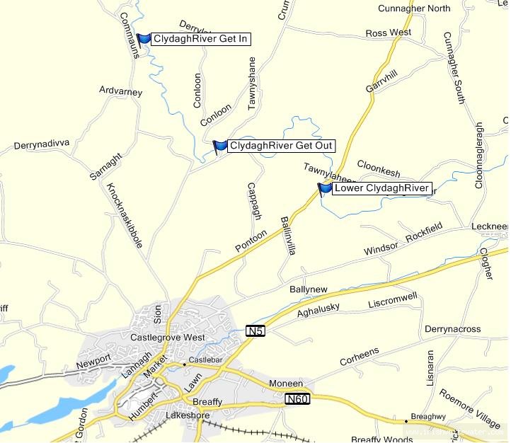
There are two sections to this run, the Upper and Lower.They are both situated 7mins and 4mins from Castlebar Town.
Upper Section: Take the R316 out of Castlebar towards Pontoon. Almost immediately outside the town is a turn to the left up a hill, signposted for the Windy Gap. Follow this road for about 2km until you reach a right hand turn signposted (sli D'humbert). Take this turn. Take the right fork after about 5km and the next left fork/turn. You should almost immediately cross a stone bridge. This is the take out. Continue up this road and take the first left. Continue along this narrow road for a couple of km. Take the next left. Follow the narrow little winding road till you get to a steel bridge and ford crossing point. This is the put in. You can park 100m further up the road beside a disused old prefab house.
Lower Section: Take the R316 out of Castlebar towards Pontoon.2.8miles from the turn off out the road there's a roadside statue of mary with a disused bridge on its right and a new bridge on the left. immediately after the bridge on the left is a car park. Park in the car park and use the nature trail to inspect. This is the put in and take out.
See put in instructions.
Interactive map loading...
Bryan Fennell