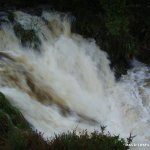
4m drop at start then a few small drops over bedrock then tree lined easy water
Not worth travelling a long way for but a useful add on to a run on the Upper Bandon or Coomhola.
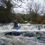
To get to the put in follow the walkers trail along the right hand bank of the river, cross the river below the drop and walk back up to the eddy immediately above the drop. Castledonovan cascade.(class4)
4m drop run from eddy above left heading right. Can be done as a park and huck.
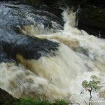
Followed by succession of small drops over bedrock.(cl3) After a few hundred metres river calms to grade 2. Stays like this till first bridge. After trees close in for 1km but never completely block river.When you get to point where left bank has been cleared of trees beware, rapids begin again. Small island in river. Go left (right blocked by tree strainer)At high water may be portage but at normal flows you can get through to the 3 drops of about 1m each. Stoppers here in high water. Last one has block in centre of landing zone so left or right but not centre. 50 m of trees before next bridge.
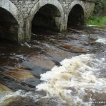
Stepping stones below bridge. Use stone on extreme left as gauge.
5cm below top of stone Min level possible.
Level with top of stone Medium water
5cm above stone High water
Confluence here followed by tricky undercut rapid (inspect on way up) Boof off centre rib of rock.(3+)
Grade drops to 2 again for final stretch to take out
4m drop at start Trees a hazard in HW but in MW you can run it all without exiting boat.
Ramblers have opened up this river. Path down most of it. Hats off to all the farmers that have worked hard to make the trails and allowed access across their land.
Ahafunshion bridge, roughly at the mid point. It's at the bridge between the put in and take out.(see the directions)
West Cork, just north of the village of Drimoleague on the R586 main road from Dunmanway to Bantry.
Turn right in Drimoleague opposite the filling station. At top of hill (1km) road forks. Left fork for take out (100m). Bear right for put in, signposted for Castledonovan
After about 1km the road to the Put In drops to an obvious parking place at a bridge. This is mid point and useful for gauging height of river.
Continue on roughly 2km on the main road to next crossroads at Garden paving centre 2km and turn left. About 1.5 km will bring you to Castledonovan school. Find parking area for walking trail 100m further on. Total about 5km from Drimoleague.
See directions for put in. On the river its the third road bridge. The nice ramblers have even put in stone steps to the river's edge upstream left of bridge.
Interactive map loading...