Lowerymore River

Donegal, Ulster Grade: 3 - 4 0.5

Brief Description

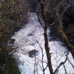
A short steep half man-made beautiful gorge section, the river right route. (1 of 2 routes)

A set of 6 man-made steps leading to a natural gorge then a further steeper 9 man-made steps.

River Description

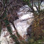
You need to have a look for yourself, requires some scrambling, but have a look from top and bottom as most is hidden.

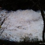
At low to medium levels there are no hazards. The pour overs are not strong with a lot of airated water.

Look at the top 6 steps and if there is enough water going over the tongues then its runnable and fun.

Gorge section narrows and water is stronger leading quickly to a set of 9 steeper steps. These are closer together and you may hit the next wall if you don't boof enough, though difficult as so much air in water its hard to keep boat from submerging a bit.

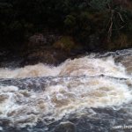
Then run easy bimble to end.

Safety & Access
Hazards
Unknown yet in high water. Just check for usual trees hazzards or flood debris.
Access Issues
Fishermen possible in season. No issues known about hydro access.
Water Level Information
Look at the top section of steps, this will let you know.
Directions to Put-in
On the main Donegal to Ballybofey road, the N15, about 2 km south west of Barnesmore Gap on the road towards Donegal Town. A set of large Steel gates at a disused picnic area is put in and get out.
Directions to Take-out
Where the 2 route meet at the hydro building.
Map

Interactive map loading...

Location & Navigation
GPS Coordinates & External Maps
Putin

Put-In

Lat: 54.6911460 Lng: -8.0109880

Version Information
Version: 0
Last Updated: 09 Oct 2008
Author: Stu Hamilton
River Statistics

1

Versions

GPS Points

8

Photos

0

Videos