King's River

Wicklow, Leinster Grade: 3 - 4 5 km

Brief Description

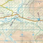
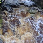
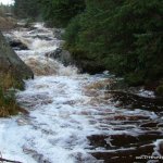
The King's River is a bouncy, fun run with a few holes to avoid. Not as good as, but a refreshing change from, say, the Upper Liffey.

The Annalecky Brook is an optional add-on at the start. It's narrow, shallow, twisted, and nasty. On the up side, it's quite short and easily skipped.

River Description

The Annalecky Brook opener is only runnable with lots of rain (it's visually obvious if it up). It's a classic Wicklow ditch with encroaching trees and narrow lines. It's also very short - a couple of hundred metres. If there's not enough water, or if you don't like the ditch, you can skip it by walking down to the confluence with the King's River proper. This is a wider river with several holes to catch the unwary and you'll need to keep an eye out for encroaching trees. It picks up in intensity as you go along, with the 'surprise' hole right at the take out.

Upstream of the confluence on the King's it looks like there might be further fun, but I don't know if anyone has run that section or where you might get in - probably a forest hike from the road.
Safety & Access
Hazards
Annalecky Brook is shallow, rocky, tree-strewn, but inspectable before you put on; the King's River has holes and encroaching trees.
Access Issues
No issues so far, but hiking to the confluence means walking a forestry road for two minutes, so it's probably best to be quick and discreet.
Water Level Information
It needs to be raining when you're there for the Annalecky section to be running; the King's River is bigger volume and will be easier to catch at various levels, but it's only really fun when it's in good water.
Directions to Put-in
The King's River rises beside the R756 road from Laragh to Hollywood and empties into the south end of Blessington Lake. The Annalecky Brook links the road with the King's River.
Directions to the Put-in:
From Laragh village, it's 20 km to the put-in - you might want to clock this as you go, because the put-in is fairly nondescript. Start out heading towards Glendalough on the R756. At the outskirts of Glendalough stay on the R756 up the right fork, signposted for Hollywood. When you cross over a white-railed bridge, park in the space on the right. For the Annalecky Brook, put-in on river-right downstream of the road bridge. For the King's River, hike down the Annalecky Brook for two minutes on river-right to the confluence.
Directions to Take-out
Continue from the put-in bridge west towards Hollywood. After about 5 km you cross over another small stream, after which you take the first left down a dirt road to the bridge. Park on the open ground on river left.
Map

Interactive map loading...

Map Photos
Kings river map

Kings river map

Peter

Location & Navigation
GPS Coordinates & External Maps
Putin

Lat: 53.0572230 Lng: -6.4263300

Version Information
Version: 1
Last Updated: 21 May 2008
Author: Jim Kennedy
River Statistics

3

Versions

GPS Points

6

Photos

1

Videos