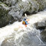
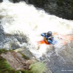
Good class 3 play water with a couple of trickier rapids.
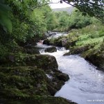
From start about .5 km flat water. Then a sharp right hand bend (good squirt spot) and a couple of small waves lead to another bend to left. The rapid here has good wave, flat spins are possible. Then there are easier rapids for 1 km.
Look out for a rapid where a rib of rock crosses the river on a bend causing a 50cm drop, because the next rapid is tricky. Stop to inspect river right. The canyon section, the entry to this rapid funnels all the water onto a large boulder (Pinning potential is huge). This can be run at levels over 1.4m
Below this level the usual line means picking your way through the shallows on the right and dropping off the ledge into the middle of the canyon (1m).
The second rapid down is a pour over type play spot (better at lower levels). Good boof needed here in big water.
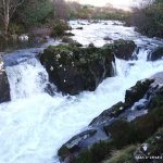
Flat water leads to the P.O. Bridge Rapid beneath the bridge, its grade 3+. (4 in hw)
on bend after bridge a good wave/hole forms in medium water
If continuing on to the mouth of the river, flat water leads to a class 3+ rapid about four different lines are possible. Then more flat water till the last rapid. This rapid varies according to tide between a big volume class 3 and a nasty undercut 5!
In higher water it is possible to add about 4 or5km of 2/3 to the run by starting higher up, just before a sign announcing the borlin valley
Trees are a problem in big water. Set up safety for the final rapid if you run it.
Its on a privately owned fishing river so access is not possible from May 1 to Sept 30. Please respect this for the sake of local paddlers who have good relations with the anglers. And there's usually little water during the fishing season anyway.
The gauge is between the two takeouts on side of a pump shed. 0.6 to 0.8 seems best for the pour over spot, 0.8 and up for running the river
1m is a good level, 1.5 and up you can run the straight line in the canyon.
1.8 is flood level and things are getting serious with few eddies
Situated in West Cork about 6 km from Bantry.
From Bantry head for Glengarriff on the N71. After 2.5km from Ballylickey village turn right (signed Coomhola/Kilgarvan). Drive another 2.3km to Coomhola P.O. bridge, you'll reconoise it because it has a green post office box by the sign post and a stone Coomhola sign.
At Coomhola P.O. bridge cross the river and turn left. Drive along the river 2km to next bridge, which is the first road on the left. This is the put-in. It is better to leave only one vehicle here and the rest at the take out.
Two take outs are possible, one shorter take out just below Coomhola post office bridge. A gate in the wall leads down steps to the river just opposite the (now permanently closed.
The next take out is longer, about 2km downstream just before the last rapid. Recognizable as a big sweeping bend right next to the river with a large lay-by and double height crash barriers or 0.5 km farther still at Snave beach if you run it
Interactive map loading...