This is a very short run. On the plus side, it holds water very well and runs when other rivers around have dried up, and you can hop off at the end and quickly walk back to the start.
On most levels it can be a bit scrapey, but the rapids still go. There are two main rapids.
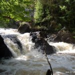
From the put in, it is about 300m to the first rapid under the bridge. This is grade 2 water.
There is a small siphon on extreme river left under the bridge. It would be difficult to put your boat into this, but it is worth identifying in case of a swim upstream of it.
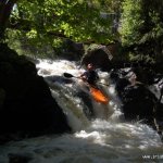
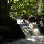
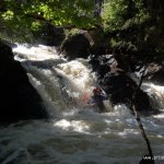
There are a few small holes on the lead in to the 1.5m drop that could slow you down a bit. On higher water levels the hole at the bottom of the drop becomes more sticky and needs to be boofed. There is a pool after this.
About 100m downstream through some small rapids and overhanging trees, there is a 3m slide. There is a channel cut through the rock slab that runs river left to right, and this gives the most fun route down. On higher water levels the water runs over the whole slab, and any line can be chosen.
From here, the take out is about 100m downstream on river left.
- Siphon river-left under the metal bridge
- In high water very large stopper forms under bridge making passage unlikely without boat or body (or both) striking bridge.
- Considerable metalwork from old mill? still in situ.
Please park respectfully – Oughterard is a busy town, especially during the summer.
The river is fished, so please try to avoid paddling through fishermen's lines or anything like that.
Check from the metal bridge. If the rapid looks like it has enough water to run, then go for it.
This run is located on the outskirts of Oughterard town. Take the N59 from Galway for about 25km, drive straight through the town and take the right turn over the bridge before the church, and turn left after the bridge to follow the river upstream. Pass the Waterfall Lodge B&B on the left and park where it is convenient.
Just after the B&B, a walkway turns off the footpath, and is marked 'Golden Mile Start'. Take this path up, cross a metal bridge over the river (have a look at the drop), continue to the end of the path and turn right on to the road. A green area soon appears on the right. Embark here.
After the slide, continue for about 100m and take out river left to the footpath, before the bridge to the trout hatchery.
Interactive map loading...