Approximately 500m of gentle class 2/3 rapids with a 3m (~10ft) drop at the end.
After getting on the river on river left above the road bridge there is a rocky gradient just before the bridge, after which the river levels out again.
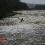
The run continues in a series of three small drops / rocky gradients and quite flat sections. River middle-right seems to be the handiest line, though there aren't really any hazards, so read yourself.
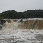
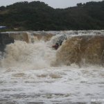
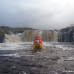
The river flattens out again – watch for the horizon line and get out above the fall to scout if necessary. The fall is approx. 3m (~10ft) with a deep plunge pool below. The fall is good to run again and again and is very safe.
There is a tight channel on river right of the main fall that is also runnable but a little trickier (This has now got a wooden plank bridge over it, runnable by lying back on to your back deck in lower water only You wouldnt fit in higher water.)
Fishermen have been known to place a metal cage below the last fall to stop poaching, so check before running. This is very rare, however with only anecdotal evidence of it.
There is now a bridge across the right channel, caution should be exercised and only be run in low water.
The river is fished, so check for fishermen.
A ban on running this river seems to be in place, going by the big red sign on the fence. Does anyone know if this is permanent?
UPDATE ON KAYAKING BAN: there is a kayaking ban in place between the end of May right up to the end September due to the salmon fishing sesson. From 1st Oct you can run it right up till May. PLEASE NOTE: Please respect the land owner's by not paddling during the Summer Salmon Season. Myself and other members from Sligo Kayak have spoken to one of the land owner's on this issue of the lack of info on his sign's i.e. (dates of season). The sign's will be taken down on the 1st of Oct. Hope this helps
Update 2026: The land owners are happy for paddlers use the river, the river right bank and falls are owned by the same land owner who lives at the top of the river. we had a conversation with him in 2024 and he only asks that we respect the fishing and spawning seasons and when leaving the river do not put boat on the fense at the bottom as he has to then replace the section. the path is owned by another land owner in mullaughmore and he is very happy for paddlers to use the river and was delighted when he was asked prior to us hosting an event there.
Water levels on the river have been known to change quickly, so scout if there's any doubt.
Sometimes the drop can become un-runnable if there has been too much rain in the last few hours. The river is fed from the Dartry mountains / Benbulben and can rise to unrunnable and fall again within a just few hours.
On the border between Co. Sligo and Co. Leitrim on the N15. The run starts above the bridge over the river, which is signposted. There is ample parking by the bridge.
Take-out is from the pool after the fall, or break out and get out above the fall if you prefer. Walk back up the river-left bank.
Interactive map loading...