A short paddle with a few weirs and a couple of good playspots. Holds its water well thanks to the big catchment and will be running when most other rivers in the area are unpaddleable. However if there has been heavy rain in the last few days it will more than likely be too high.
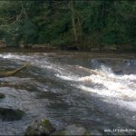
If you chose the two car get-on, you have is one small weir at the get-on (put at this weir, above or below as you fancy) and a short flatwater paddle to warm up with before you come to the first major weir. This weir is an L-weir with a fishbox down the middle. Run either side you want, left of the fishbox is probably the most fun with a small boof at the bottom. 500m after you come to the Triple Steps.
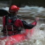
There are a number of ways to run the first part. As a general rule, the far left and far right sides are no-go's, both land onto rock. The river left hand corner of the drop, the canoe chute just left of centre, and just right of centre are the best lines. If you haven't run this before I'd advise you get a look at it before you run it, partly to get an idea of the lines so you don't land on rocks, mostly so that you know that the river isn't too high, as this drop forms some seriously meaty stoppers in big water! The next two steps can be run river-right, with a chicken-chute on river left if there is enough water. This is a great drop to session, with a good few different lines to check out. There is a small concrete pier here in the pool which is ideal for getting out and walking back up to the top of the rapid. The pool at the bottom of the drop is fairly popular with fishermen, though I have never heard of anyone having any aggro with them here.
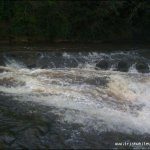
There is a small broken weir after this, run left. After this, a V-weir, just run it straight down the middle. The weir forms a wave in higher levels. If you so fancy, you can take out on river right on the beach and head back up to the put in to run it all again.
On downstream there are a few minor rapids and playspots. The hole with the rock protruding in the middle of the hole is known as the looping hole and is the take-out for the shuttle-less run. on river left . If you have another car at the bottom, continue on past this until you reach the take-out at the jetty.
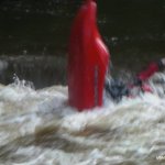
Landing on rocks/stoppers of doom in high water at Triple Step.
A kayaker died at the L-weir many, many years ago, though the weir has since been rebuilt.
No problems, just park considerately!
The best gauge is the Triple Steps. If it like you'll scrape down it, it'll go, but the other weirs will be the same and the playspots will not be working. If it's too high the triple steps will be a nasty looking mess of stoppers and boils. The L-weir will also be unrunnable at this level.
Benburb village is about 10 mins off the A4, close to the end of the M1 motorway from Belfast. Coming from Belfast, continue once the motorway ends until you reach a roundabout, take the first exit towards off onto the B45 signed for Benburb.After about 1km take the left fork in the road. Continue along this road until you come to the village. Take a left turn in the village and follow the road for 500m til you reach a right turn, take this road. Keep on going and you cross a bridge and there is a car park on the right. This is the get-off. Shortly past this there is a fork in the road, take the right branch.
There are two choices of put-in. One is at the Benburb Heritage Centre. To get to this continue on past the fork and turn right when you reach a junction with a house on the corner. Continue on down this road and turn right and right again at the heritage centre. Drive through the courtyard between the buildings and here you are!
Alternatively for a shorter, shuttle-less paddle, take the right fork after the get-off car park and continue a short way up the road until you reach a right turn down a lane which is almost turning back on itself. Drive a short way down here and you\'ll see the river on your left. There\'s good parking space next to the abandoned building on the right. To get to the river, go through the gate down a green-lane, and continue til you get to a wooden fence above a weir. Scramble down the bank and put in here above the L-shaped weir. Try not to block the lane please, it\'s used quite frequently by walkers and anglers.There are two takeouts. If you have a car in the bottom car park take out once you reach a jetty on river right with a set of steps leading up to the car park.
If you have just the one car, take out after the looping hole on river left on the gabions, walk back up river along the track, across the white bridge, keep heading upstream taking the path that follows the river and you will come to a gate and a road. On up the road will be where you parked your car.
Interactive map loading...