Depending on water level this is either a scrapy III with Jacksons Falls (IV-c) (low water) to a really continuous III+/IV- with Jacksons (IVd) high water with Little Jacksons becoming (Ve) in mega high water (when the main falls is washed out - very rare).
Lough Dan to Annamoe village: normally done as an additional 3 miles of grade II+/III+ when the river is high at Annamoe village. everything boat scoutable with obvious lines. two or three III+ rapids.
Annamoe to Trooperstown: more II+ with some easy III. halfway, you'll pass under a bridge. the next rapid is called Guinness' (III/III+) and is well worth a scout if you're unfamiliar with it, as a stylish head-rudder over the second part can end with a rearranged smile.
Trooperstown to Ballard (Bookies) (III+ Jacksons IV-): 300 yards down from the bridge there's a rapid called Trooperstown Rapid (III+) that's worth a look for those who are unfamiliar with the river. This has had major changes done to it. It could form a powerful stopper in high water. When the river passes over a shallows with trees on the right, you are at the start of the first boulder garden (III) shortly downstream when you turn a corner and can see two large boulders in the river on river right you are at the second boulder garden (III/+) about 500 yards after the second boulder garden you reach the entrance rapid to Jacksons, signalled generally by passing over another riverwide shallows.
Jacksons (IV-c): The entrance rapid is quite long. As you are wombling down this rapid stay center and when it becomes obvious that you are approaching the falls stay left. You will pass a shelf which spans three quarters of the river from the right bank. This bar forms a nasty to really nasty tow-back stopper in medium to high water and is generally where any painful Jacksons run has its origins. Below this bar there are eddies left and right, again below the next small rapid there are big eddies left and right above Jacksons Falls. Tradition is to take out river left at either of the eddies and set rescue in the bottom on the left in Jacksons depending on the strength of your group. Inspect/boat scout/run Jacksons and Little Jacksons. As I mentioned above, this drop varies in severity and difficulty and consequences depending on water level. (IV-c low water/ IVd medium to high water/ V-e mega water due to horrific terminal stopper at Little Jacksons). There is a rock called 'Fernando' in the middle, of this fall, which has a taste for the damaging the nose of boats.
Take out 100 yards down on the right for the path to Lynhams' Hotel or one mile down for Ballard Bridge exit on river left after the bridge.
Jacksons is grade 4 to 5 (IV-c to V-e).
- Cars have been broken into at Trooperstown Wood car park and at Ballard bridge. As usual park sensibly.
- Do not block the road beside the handball court at Annamoe Bridge. It is a private road.
-Lyhnams are happy to have kayakers in the area but please be respectful using their carpark.
- Try to change out of view
- Dont litter the carpark with boats and equipment.
- Try and use Ballard get out if the Village is particularly busy.
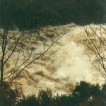
Looking downstream at Annamoe bridge.
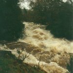
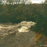
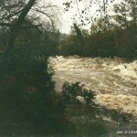
If lots of rocks are showing and the stretch looks un-paddleable, the river is low so proceed to Trooperstown for a more accurate assessment. If all the rocks are covered and it looks like a boat might float down down over the shallows, the river is medium. If the river is brown and muddy and moving quickly, the river is high. At Trooperstown: if the line of rocks are fully out of the water with no passable channel, go somewhere else. If there is water flowing around the rocks and it looks like you can pass the small rapid below the bridge comfortably, the river is low, if the water is lapping near the top of the rocks the river is medium, if the water is flowing over the rocks the river is high.
Even when the river exceeds the rocks the river has the potential to rise immensely. With excessively heavy rain this river will change hugely. So be careful unless you want floating cows to among the hazards you will encounter.
The online gauge is here:
irishwhitewater.com/gauge/
(The gauge is no longer operational do to on going vandalism)
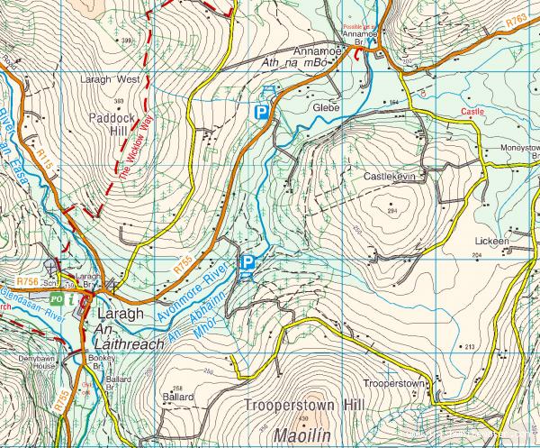
From Dublin. Get to the M50 and follow it south (M11) until you get to Kilmacanogue and turn right for Roundwood/Glendalough. Straight through Roundwood heading for Glendalough.
There are three put-ins:
1. Lough Dan (long section).
From Dublin turn right at the main crossroads in Roundwood and follow signposts for Lough Dan adventure centre until you cross the river at a bridge over the Avonmore. Put in here. From Laragh head back in the direction of Roundwood and take the second left after crossing the Glenmacnass river in Laragh (small road up a steep hill) follow this road until you come to a Y and turn right. Put in at the bridge 300 yards up from the junction.
2. Annamoe (regular section).
Put in at the bridge in Annamoe village.
3. Trooperstown (short section).
Continue through Annamoe village for another 3.2 km in the direction of Glendalough, turn left into Trooperstown Wood (signed) and put in at the bridge.
All sections take out at either the confluence with the Glenmacnass and walk up the track to the carpark behind Lynhams' Hotel in Laragh, or continue downstream to Ballard bridge. To get to Ballard bridge drive through Laragh onto the Rathdrum road and take the first left. Bridge is 500 yards down. Note that the get out is river left, not river right which is private property.
Interactive map loading...
Annamoe bridge to Bookey's bridge
Peter